| Please be mindful of todays weather. We are to get a lot of rain today. Please take precautions to stay safe at home and on the road. They are predicting flash flooding which can occur very rapidly and change quickly. Do not drive tbrough standing water - Turn Around, Don't Drown! Leave extra time to get to where you need to go. Know how to get there using alternate routes, that will not be flooded. Please be safe!
• Excessive rainfall associated with Ida combined with pre-saturated conditions will likely result in considerable flash, urban, and river flooding impacts Wednesday into Thursday in parts of south-central Pennsylvania.
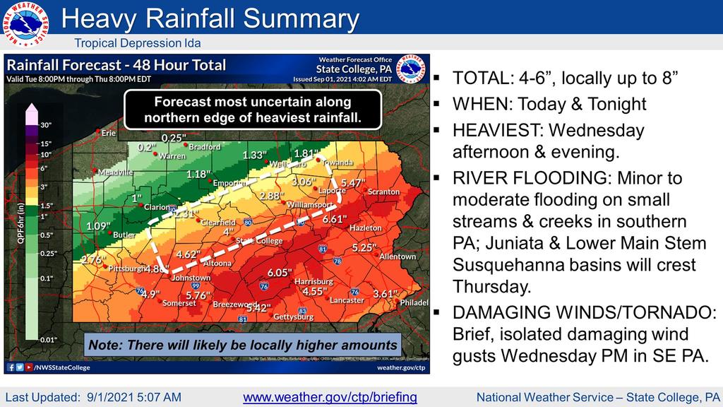
• Widespread rainfall totals of 3-5” are expected across south-central PA with locally higher amounts up to 7” possible.
• Several streams and creeks are expected to reach minor to moderate flood levels in the Juniata and Lower Main Stem Susquehanna basins. A few points could crest above major flood stage on Thursday.
• An isolated damaging wind gust or weak/brief tornado threat remains limited and confined to extreme southeast Pennsylvania.
Important changes: Updated rainfall totals and severe t-storm hazards. Rising probability of significant heavy rainfall and considerable flooding impacts.
Excessive rainfall combined with an already wet ground will result in considerable flash, urban and river flooding impacts Wednesday into Thursday for south-central & southeastern PA, where widespread rainfall of 3-6" is expected (and locally up to 8" is possible).
Several streams and creeks are expected to reach minor to moderate flood stage in the Juniata and Lower Main Stem Susquehanna basins. A few creeks/tributaries could even reach major flood stage.
An isolated damaging wind gust or brief tornado is possible across south-central & southeastern PA, primarily south and east of the I-81/I-78 corridor.
For more information, see attached briefing or view it online at https://www.weather.gov/media/ctp/Briefing/briefing.pdf. You can also find additional weather information at https://www.weather.gov/ctp/briefing or https://www.weather.gov/ctp/selfbrief. |